HOPKINSVILLE, Ky. (AP) – Another wave of torrential rain and flash flooding was anticipated to strike parts of the South and Midwest on Saturday, following a series of severe storms that had already left many areas heavily waterlogged and caused deadly tornadoes earlier in the week. Notably, the storms led to flash flood emergencies on Friday night in states such as Missouri, Texas, and Arkansas, while communities continued to recover from recent tornadoes that destroyed neighborhoods and resulted in at least seven fatalities.
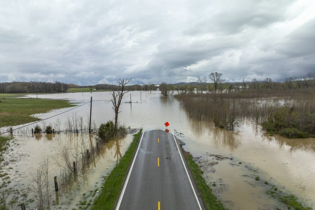
In Frankfort, Kentucky, a tragic incident occurred when floodwaters swept away 9-year-old Gabriel Andrews while he was walking to a school bus stop. Governor Andy Beshear confirmed via social media that the boy's body was located approximately half a mile from where he disappeared. Meanwhile, the downtown area of Hopkinsville, a city with a population of 31,000 located 72 miles (116 kilometers) northwest of Nashville, was submerged, prompting rescues of a dozen people by officials concerned about the rising water levels.
Local business owner Tony Kirves, who operates a photography studio, described the situation in downtown Hopkinsville as resembling “a lake,” as he and friends attempted to use sandbags to protect their property. He stated, “We’re holding ground, trying to maintain and keep it out the best we can.” In light of these developments, flash flood warnings were issued for at least seven locations across Missouri, Texas, and Arkansas, with heavy rains expected to persist on Saturday, potentially exacerbating conditions in already inundated areas.
The National Weather Service (NWS) reported that Missouri, Texas, Arkansas, Kentucky, and nearby regions could face dangerous flash floods. Approximately 45 river locations were predicted to reach major flood stages, leading to extensive flooding of critical infrastructures such as roads and buildings. In Christian County, Kentucky, where Hopkinsville is located, rainfall since Wednesday evening measured between 6 to 10 inches (15.2 to 25.4 centimeters), and an additional 4 to 8 inches (10.2 to 20.3 centimeters) could fall by Sunday, according to the NWS.
As a result of the flooding, hundreds of roads in Kentucky became impassable due to floodwaters, downed trees, and landslides. Governor Beshear indicated that road closures are expected to increase with the forecast of more rain. Flash flooding poses a heightened risk in rural Kentucky, where water runoff from mountains can quickly fill hollows. The eastern part of the state experienced tragic flooding less than four years ago, resulting in numerous fatalities.
Furthermore, the recent intense flooding could significantly disrupt shipping and supply chains in crucial corridors, including areas like Louisville, Kentucky, and Memphis, which serve as major cargo hubs. Swollen rivers in the region also inundated parts of Ohio on Friday, prompting Governor Mike DeWine to announce the closure of about 70 roads, with moderate flooding expected in the southern half of the state, a situation not encountered in four years.
Forecasters attributed the violent weather patterns to warm temperatures, an unstable atmosphere, and strong wind shear combined with abundant moisture coming from the Gulf region. Since the start of this week's weather outbreak on Wednesday, the NWS has issued at least 318 tornado warnings. The violent weather sequences have been exacerbated by staffing shortages in nearly half of the NWS forecast offices, which have reported vacancy rates of 20%, a notable increase from a decade ago due to prior job cuts during the Trump administration.
On Friday evening, tornado reports were confirmed in both Missouri and Arkansas, with the NWS urging residents in the town of Advance, Missouri, to take immediate cover. Earlier in the week, severe storms led to the deaths of seven individuals in Tennessee, Missouri, and Indiana. In Tennessee, Governor Bill Lee described entire neighborhoods in the town of Selmer as “completely wiped out” after being struck by a powerful tornado with estimated winds reaching up to 160 mph (257 kph). Advance warning of these storms likely mitigated further casualties as many took shelter in local courthouses.
In Arkansas, a tornado near Blytheville lifted debris to heights above 25,000 feet (7.6 kilometers), and the state’s emergency management reported damage across 22 counties due to tornadoes, wind, hail, and flooding. Additionally, the Mississippi governor reported damage to at least 60 homes, while in far western Kentucky, four individuals were injured while seeking shelter in a vehicle under a church carport as the storms ravaged the area.